Home › Festivals › Busan International Rock Festival
Busan International Rock Festival 2026
- 📅 Dates
- Oct 2, 2026 – Oct 4, 2026
- 📍 Location
- 29-50, Samnak-dong, Sasang-gu, Busan
- 🎫 Admission
- Paid
- 🕘 Hours
- 10:00~22:00
- 🎪 Venue
- Samnak Eco Park
- 🏛️ Organizer
- Busan Metropolitan City · Busan Festival Organization
- ☎️ Contact
- +82-51-713-5000
Overview
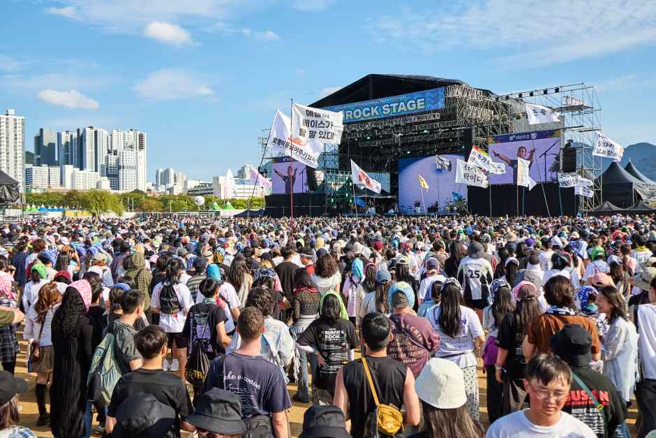
First held in 2000, the Busan International Rock Festival is Korea’s first and longest-running international rock festival. In 2026, the 27th edition will take place over three days, from Friday, October 2 to Sunday, October 4, at Samnak Eco Park, featuring a diverse lineup of Korean and international artists. Stages set throughout the park will showcase everything from emerging talent to world-renowned headliners. Beyond the performances, visitors can also enjoy a variety of festival attractions, including interactive games, food court lounges, camping zones, and other special side events.
Source: Korea Tourism Organization (official English translation, TourAPI).
What happens at Busan International Rock Festival
- Busan International Rock Festival
- Rookies on the BU-ROCK
- Road to BU-ROCK
Official programme as registered with the Korea Tourism Organization. Details can change — check with the organizer before you go.
🇰🇷 Copy this into Naver Map or Kakao Map
Google Maps cannot give walking or transit directions inside Korea — Korean law restricts map-data export. Naver Map and Kakao Map can, but they find far more when you search in Korean. Copy and paste:
📊 How busy this area gets
Visitor-volume index for 사상구, from Korea Tourism Organization big data. 1.00 = that area's own yearly average, so this compares the area against itself — not against Seoul.
Oct — 1.10 · quietest of the months we have
The index covers the whole district, not the festival ground itself. Use it to pick a month, not a day. · Oct 1.10 / Sep 1.17
🅿️ Nearby attractions — with actual parking capacity
Most sites only say "parking available." These are official figures from the Ministry of the Interior and Safety, so you can judge before you drive.
Names and addresses here stay in Korean on purpose. Google Maps cannot give directions inside South Korea, and NAVER Map / KakaoMap find these places only under their Korean names — copy an address above and paste it straight in.
🏮 Traditional market days during the festival
Korean country markets open only on days ending in fixed digits — every 5 days. These are the actual dates they open while the festival runs, so you can add one to the same trip.
Names and addresses here stay in Korean on purpose. Google Maps cannot give directions inside South Korea, and NAVER Map / KakaoMap find these places only under their Korean names — copy an address above and paste it straight in.
🎪 Other festivals nearby at the same time
Overlapping dates, within 60 km.
Nearby Attractions
Places within 12 km of the festival venue (straight-line distance), described in English by the Korea Tourism Organization. Travel time depends on roads and traffic, so only distance is shown.
-
Samnak Eco Park삼락생태공원 Attractionapprox. 0.8 km
Samnak Eco Park is the largest among the four riverside parks created along the Nakdonggang River. Covering an area of 4.89 ㎢ and stretching 7 km in length, it is a…
Korean address for map apps부산광역시 사상구 삼락동 29-46 -
Daejeo Eco Park대저생태공원 Attractionapprox. 4.4 km
Daejeo Eco Park is an ecological park stretching from Gupodaegyo Bridge to the Nakdonggang Estuary Bird Sanctuary. It encompasses various wetlands and waterways,…
Korean address for map apps부산광역시 강서구 공항로 1246 (대저1동) -
Barog Clinic (Deokcheon)바로그의원 (덕천 Attractionapprox. 5.5 km
Barog Clinic (Deokcheon), first opened as Yeppeuda Clinic, has steadily expanded over the past seven years and is now recognized as a reliable provider of high-quality…
Korean address for map apps부산광역시 북구 만덕대로 24 -
Olive Skin Clinic올리브피부과의원 Attractionapprox. 5.6 km
Olive Skin Clinic is a specialized dermatology clinic located in Busan. The clinic is specialized in lifting, anti-aging, pigmentation disorders, acne, and scar…
Korean address for map apps부산광역시 북구 만덕대로27번길 3 -
Seunghaksan Mountain승학산 Attractionapprox. 6.6 km
The 496-meter-tall Seunghaksan Mountain, named for its terrain's striking resemblance to a flying crane due to its steepness, offers five hiking trails. The mountain…
Korean address for map apps부산광역시 사하구 하단동
Google Maps cannot provide driving or transit directions inside South Korea. Paste the Korean addresses above into NAVER Map or KakaoMap — both work with these addresses and are what people here actually use.